
This draws you a plot of the height of the terrain between your base station and a distant station, as the crow flies[1].
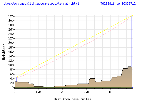
A picture's worth a lot here - this is the output if you take the default values for the Grid ref of the base station, and of the distant station. Which happen to be set for BBC broadcasting House, London, and Crystal Palace, London. Okay so BH is the home of Radio but it'll do for an example.
You need to find the National Grid ref of your home - http://www.streetmap.co.uk/ can help you with that. Enter your town, and click on the map near your house.
| Don't click exactly on your house but on the nearest large road. I don't collect the data but I don't want the responsibility if some evil scuzz is watching either of us with an eye on your new widescreen plasma telly or radio gear! The height data is only accurate to 0.5km grid squares so you won't lose out... |
Take the link 'click here to convert the coordinates' which is in tiny text underneath the map. The grid ref is the LR row, and will have two capital letters followed by six digits, like TQ288816 in the case of BH.
For a two-storey standard British house, a loft aerial is about 10m above ground level and a roof aerial is about 15m a.g.l
You next need to find out your local transmitter, it's grid reference and the height of the transmitting aerial above Ordnance Datum (AOD)[2] OR the height above ground level. If you enter both, AOD will take precedence and height above ground will be discarded. Height AOD is preferred as it will be the result of a professional survey of exactly the mast location and therefore more accurate that the 0.5km grid resolution of the elevation data.
It'll be a lot higher than yours - 100m typical but you can find this out from these places
http://www.bbc.co.uk/reception/ ( the BBC have a really bad habit of swapping their site about so if this link is dud enter reception in their search box)
http://tx.mb21.co.uk/info/index.asp
http://www.wolfbane.com/articles/tvr.htm
Once you have that info stick the data in the boxes, hit the do it button and you should have a plot and some summary information. Your aerial and their aerial will be shown, along with any intervening terrain. The yellow straight line is your line of sight path - if it's uninterrupted by the terrain then you're in luck. The pink line shows the limits of half of the first Fresnel zone. Terrain penetrating this will give you some signal loss by diffraction even if the line of sight is clear. An average wavelength of 0.5 m is assumed, corresponding to the middle of the UHF TV band.
As a rule of thumb, intervening terrain close to the aerials gives you more problems than stuff midway. There isn't usually much in the way of the transmitting aerial because broadcasters choose their sites to avoid that. Your end, of course, is a different matter - if you print out the page you can use a ruler to clear obstructions from the transmitter aerial on the right hand side, and read off the height your aerial would need to be to get a line of sight path from the height axis on the left.
| As with all things radio, this is an approximation. The resolution of the data is every 0.5 km - you don't tend to get significant hills smaller than that but there may be exceptions. No account is taken of man-made structures or vegetation. You should, however, be able to spot if you have big hills in the way you might not have taken into account, and recognise other features. F'rinstance, the dip to sea level about 2 miles from BH in the above plot is the Thames - Crystal Palace is south of the river, but BH is north of it. |
Let's go -
This page is an online implementation of a program used by UK radio amateurs since 1993. Credit is due for the original Power Basic design, logic and implementation Andy Talbot G4JNT
Selecting and siting your TV aerial
Why DTT is different from an analogue install
![]()