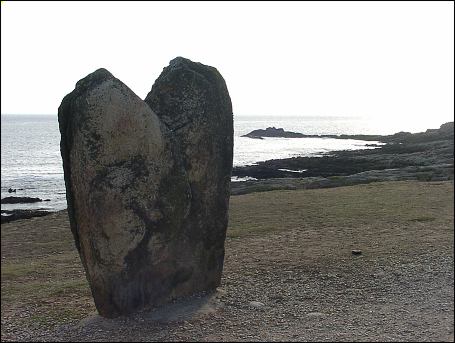
le Vivier

le Vivier
Type:Standing Stone
Country:France
County:Brittany
district:Morbihan
Grid Ref:
Latitude:47.484040
Longitude:-3.141519
Accuracy:to 15m (GPS with SA off)
Datum:WGS84
Date:September 2002
local map:view map
View in Google Earth:KML file
le Vivier Standing Stone
nearby sites
KergalloStanding Stone, 0.3km away
ManémeurStanding Stone, 0.5km away
Port PilotePassage Grave, 0.5km away
Manémeur IIStanding Stone, 0.7km away
GoulvarsStanding Stone, 3.4km away
Pors-GuenPassage Grave, 4.6km away
Le MénecAlignment, 12.9km away
KermarioAlignment, 13.6km away
Géant du ManioStanding Stone, 14.8km away
Kerlescan alignmentsAlignment, 15.0km away
Mané KeriavalPassage Grave, 15.2km away
Petit MenécAlignment, 15.6km away
CrucunoPassage Grave, 15.6km away
Pierres PlatsDolmen, 16.4km away
Kerzerho AlignmentsAlignment, 16.8km away
These two stones straddle the highway - the seaward side heart-shaped stone is set in concrete which is dated July 1984, presumable it was reset because was based in the sand
 

M E g A L i T h i A
Text and photographs © RM 1992-2007 unless otherwise credited
Last updated 18-Mar-07