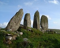
Eightercua

Eightercua
Type:Alignment
Country:Eire
County:Kerry
Grid Ref:V512696
Latitude:51.858952
Longitude:-10.160107
Accuracy:to 70m (NGR derived)
Datum:WGS84
OS Map:OSI Discovery sheet 83, Kerry
Date:June 2000
local map:view map
View in Google Earth:KML file
Eightercua Alignment
nearby sites
Dromkeare Alignment, 3.0km, V540684
Dromod Stone Circle, 3.3km, V545694
Doory Alignment, 3.7km, V546710
Derrineden W Alignment, 5.8km, V567713
Derrineden E Alignment, 6.3km, V572716
Fermoyle Alignment, 6.5km, V453724
CoolsStanding Stone, 9.9km
Garrough Alignment, 9.9km, V558608
CahersiveenStanding Stone, 10.4km
KeelStanding Stone, 11.5km
Kildreelig Alignment, 12.0km, V408637
Derreenauliff Alignment, 14.0km, V632624
ToonAlignment, 14.0km
ToonStanding Stone, 14.2km
FeaghmaanStanding Stone, 14.4km
Reaching the tall fingers of Eightercua is a majestic sight, particualrly if you are taking in the natural beauty by touring the Ring of Kerry. The tallest stone is 3m high, and the alignment is a good fit to line up on the midwinter sunset (33).

The stones are visible from the N70 highway (on the left if heading for Kenmare)


 view of stones from road

view of stones from road

M E g A L i T h i A
Text and photographs © RM 1992-2006 unless otherwise credited
Last updated 09-Jul-06